archives & links below

My photo
A person who needs no introduction.
Showing posts with label history. Show all posts

Friday, August 28, 2020

Stalking the Wild Abutment

I didn't hurry to get to my walk today, as it was going to be cool and (knock wood) not wet in about the same proportions for a couple of hours. When I did walk, it was a lovely day, and I made good time. GREAT time if you believed my walking odometer, which reset its time after twenty minutes... while keeping my mileage! So I showed a superb average speed today, you betcha.

On the canal, I spotted a disused dock, just about the only one with no trespassing signs on it. It was a little overgrown with weeds, and has creeper on the bench. I photographed it for future reference. There's a Little Free Library not far from State Street, on the canal, and I poked through it and straightened the books and CDs out. I even tightened the latch, having a Phillips Head on my knife.

In the area back of the Del Monte motel (where we all stayed our first night in town, as our other accomodations wouldn't be ready for another day, twelve years ago), I went to the portion of the Auburn Trail that Sarah and I had walked once, from the apartment we were in for three weeks or so as we waited for this house to be ready for us. At the time, I'd seen signs that something was odd about one part, near the end. I looked down and saw some concrete. Later, I decided that was a spot where another line (I recently learned that it's the old electric car line from Rochester to Victor or Bloomfield or one of those places) crossed below, which I'd seen in a photo. This photo:


I'd almost started to think that I had imagined it, having spent some of my walks bumming around that stretch of the railroad trail, looking in the dense growth below for signs of that underpass. I'd spent time looking at what I could find online--like this photo! 

I thought I had it in a book, but couldn't find it, so I found it at a site set up by Mr. David Gardner, who had some early photos, and a map showing the path of the streetcar, which brought me to within a few paces of the spot earlier this week. Just above is a view of the elevated part of the Auburn, taken from a spot on or near the tracks in the old shot. When you're on the trail up there, nothing really tells you you're on a cement structure. It just looks like a raised right of way, except when you notice how far down the trees on either side go.


Today I walked to the spot, about to look for the thing for a couple of minutes at the apex of my walk (from home back to home was about six miles today), and there it was, plain as anything--because some men with tractors and other equipment were removing the vegetation that covered it and clearing off the front of the old underpass (which is now undoubtedly bricked or cemented in) so it can be seen from the trail. And they're putting in a bench, and for all I know a historical info sign. I thought this was great, and thanked them. The above view is looking own from the upper track bed at part of an exposed side of the underpass--it would be on your right in the old pic.


The above map shows where this took place. The arrow by "Abutments" points to where my abutment has been several times in the past couple of weeks. I used that map and a screen snap of the satellite view from Google and worked out where that spot should be, and checked the scale and estimated about a hundred paces. I wasn't far off. I also went and looked at Jojo's, which occupies the old streetcar depot (handily across Main Street from the Auburn's depot). I also located the old German Howitzer that used to sit in a park just above that arrow indicating the station. There's no sign of its base in the park now, but the Pioneer Burying Ground a mile from my house has three cement pads that used to hold the captured armament until 1936 when the other park was created. By about 1980, they decided to landscape it out of existence, and they loaned the piece to East Rochester. By a coincidence, the day after I had been reading about it, I walked around a corner of one of the paths between the Auburn Line and the canal and there was the howitzer.


A guy there told me they were looking to put the thing in the park they're creating back there, but it needs some work. He said some Mennonites were maybe going to fix the wheels and tires, but it still needed sandblasting. To add another layer of unlikely coincidence, I was telling my next-door neighbor about the howitzer, and he said that his Legion post (or was it his VFW chapter? Never mind!) had refurbished the thing in 1980. A sign on it says it was done again in another year, too. I'm deciding against buying a howitzer for my yard. Too much maintenance.

In other railroad trail news, I saw some 'new-to-me' miles yesterday when I drove (first time I drove somewhere to walk by myself) down to Railroad Mills, the street that marks the farthest south I'd gone before, and parked by Powder Mill Park, and walked to the trail and went two and a half miles (not an ambitious day, distance-wise) and saw some nice glens and woods, on a very well manicured trail with stone mile markers and reasonable signage. I reached Fishers, NY, which has a two-story blocky, knobby stone pump house that is the second oldest railroad building in the US. Though it's a very small town, they did have a Little Free Library there, and I traded the book in my pack for one they had. 

Between Railroad Mills and Fishers, however, was another little mystery.


Why, what a nice tunnel under I-90 (Dewey Thruway)! You fellows surely didn't build that there because the old railroad trail ran that way. How recently did the trains run this way? And how long ago did they build the Thruway? (On different days, I found the answers: This part of the Auburn Road was abandoned in 1960. The Thruway was built in 1954. It was just that close.)

My research this week also shows that the Trails group that was starting up in the late 1990s had considered connecting the Auburn as it crossed the Erie Canal (presently a dead end on each side) by putting a new footbridge where the railroad bridge used to be, something I'd often wished someone would do. In 2002, the job was estimated to cost $1.4M to do. No idea how much it would cost now, but that big concrete piece still stands ready in the middle of the canal. (I also learned that some abutments I'd seen when crossing the canal at Marsh Road were not from an old Marsh Road bridge, but were there for the street car line.)

Anyway, on the way back, I sat on a bench and played with my tiny keyboard for a quarter of an hour, getting back my version of Fats Wallers's "Viper's Drag" that I can play on a 31-key instrument with just two notes of polyphony. 

Getting back to today, I found the Harladay Hots stand in operation in a vacant-lot park on Main Street, and had an Andouille Sausage for lunch. Then I went home and played the piano. Life was full of fun today, and I relished it, haw haw.

.

Saturday, February 02, 2013

Here Lies Somebody

.
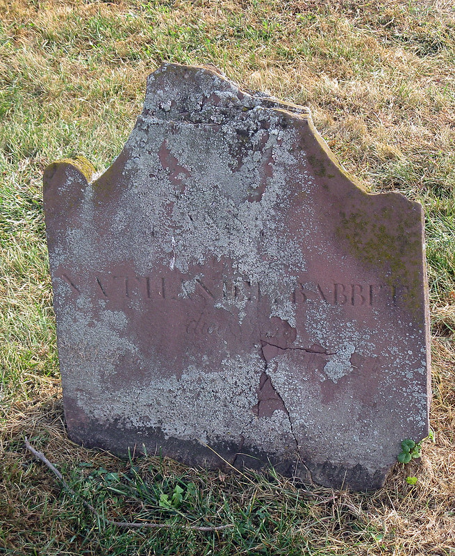
Not long after moving here, I was looking at a cemetery about a mile from our house, and found the grave of a likely relative. Likely, because (according to The Babbitt Family History), almost all Babbitts in the US were related, and traced back to Edward Bobet — with the exception of a few who had come into this country as immigrants with names the officials couldn't or wouldn't write, and who found themselves and their descendants dubbed with the surname.

Anna Babbitt 2009

It was possible to read the name on the stone: "Nathaniel Babbitt." The soft sandstone held other faint lines, but between their weak grip on the stone and the encroaching lichens, I couldn't make out any dates. I guessed that it was one of the oldest stones in the Pioneer Burying Ground, which began use just before 1800. I pored over a copy of the family history. Not the copy my grandmother had, but a scan of a library copy that I found online. Archive.org was probably the source of it. First, I tried to read the text conversion of the book, which as full of errors due to unchecked mechanical character recognition and problems with columns and footnotes. It turns out, though, that the scanned PDF version is fully searchable and looks great.

I soon found out that the family history is chock full of Nathaniels, and not knowing exactly when to look was also a handicap. I searched on Pittsford, and found references to other Babbitts, as well as to Pittsford, Vermont, which I've found is the town that the one here in New York was named after. Since this town was called Northfield at the time the cemetery was begun, I searched that as well. Guess which other state has a Northfield where Babbitts lived. Yes. Vermont. Curse you, Vermont!

Anna Babbitt 2011

By 2011, the growth across the face of the stone had expanded. I wondered if taking a brush to it would do more harm than good. I wondered if there were any descendants still in town — or in other nearby towns. The history mentioned Babbitts in other towns in the state, ranging from a few miles away on the shore of Lake Ontario to the other side of Syracuse. I tried calling a Babbitt in the phone book, leaving a voice message that hasn't been returned yet. I stopped by the Town Hall and learned that the town historian comes in for a few hours a week on Thursday afternoons, and took down her information. Months later, I remembered in time to give her a call.

She had some interesting information for me. Going to her records, she told me that the stone is not marking the resting place of Nathaniel Babbitt, but that of his wife, Anna, born 1782, died 1806 (June 1806, though the stone apparently once claimed 1804 in error). She was aware of the condition of the grave, and didn't think there was anything that could be done about it by this time.

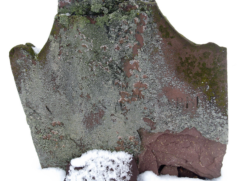
Anna Babbitt 2013

Looking at my earliest photos, I could now trace some of the letter shapes in 'ANNA' in the gray-green overgrowth. I could even discern in the gentle curves beneath Nathaniel's name the likely location of "1782" and perhaps "June." She mentioned a Babbitt family that she used to know in town, on Clover Street. The father's name was Arlo or Arliss, the daughters were Donna and "Betty" (short for Elizabeth). Donna moved to Iowa, Betty passed on.

Time has been hard on the graves, particularly those carved in soft sandstone. The oldest is unreadable now, and is part of a row of undecipherable white slabs. I thanked her for the information, which was more than I expected, even though I had been fairly sure she'd have access to records. With or without records, she knew the graveyard, and its stones, very well. I felt like I'd been taking up a lot of her time, so I didn't ask about the small stones piled up at the back of the yard. They are probably footstones that became separated from their original graves.

I still don't know how I may be related to these people. Mom died in 2008, and wouldn't have been able to tell me anything anyway for at least a decade before then. Her last surviving sister, the oldest of her generation, died last year, and her widower wouldn't be much interested in that side of the family (he apparently has Grandma's copy of the family history, which may have notes written in it that I'd like to see). My sisters and I are interested in seeing what we can figure out, but it may be too late to do a lot of that by now. Too bad. The internet makes parts of it very easy to do.
.

Saturday, August 25, 2012

walking it back

.
The greatest, most glorious retraction I ever read ran on December 17, 2003, on the front page of the first section of the Virginian-Pilot newspaper. It was part of my job to go through this paper each day. (On Sunday they had crossword puzzles from both the NY Times and the LA Times, and I'd save these pages for trips. I miss that!)

On this particular day, my eyes were greeted by a follow-up article to an original article I hadn't seen — I'd only been in the area since 1985:
WE'D LIKE TO SET THE RECORD STRAIGHT
- A CENTURY LATER

A story and headline in the Dec. 18, 1903, Virginian-Pilot contained errors.

Orville Wright was the pilot for the first flight of the Wright Flyer. It was not Wilbur, whose name is not spelled Wilber.

The plane's wing span was 40 feet, 4 inches. The wings were 6 feet 2 inches apart vertically and 6 feet, 6 inches from front to rear. They were covered in muslin, not canvas.

The engine rested on top of the lower wing. It did not hang below it.

The propellers had two blades each, not six. They both were mounted on the rear side of the wings. There was no propeller providing upward force.

Rudders in the front and rear and warping of the wings controlled the plane. There was not a single, huge fan-shaped rudder that could be moved side to side and raised and lowered.

The pilot lay prone on the lower wing. There was no pilot's car.

The Wrights have always said they were equal inventors of the machine. Wilbur never took credit as the chief inventor. The brothers had no plans to build a much larger machine and never did.

Their success came after four years of work, not three.

They took one trip to the Outer Banks in the summer and two trips in the fall prior to 1903. They did not spend almost the entire winter, fall and early spring on the Outer Banks for three years.

They arrived on Sept. 26 in 1903, not on Sept. 1.

The plane took off under its own power after traveling 40 feet down a rail on flat land. It was not sent down a slope after Orville Wright released a catch. The engine was started before takeoff. It was not started after the plane had rolled halfway down a 100-foot hill.

The plane flew 120 feet, 8 to 10 feet off the ground in a straight line on the first of four flights. It did not soar 60 feet in the air. It did not circle and fly 3 miles over breakers and dunes. It did not tack to port, then to starboard.

The plane's ground speed was 8 to 10 mph. Its air speed was 30 to 35 mph. It did not fly at 8 mph.

The plane hit the ground nose-first after its fourth flight, damaging the front rudder mechanism, and was later destroyed by a gust of wind. It did not descend gracefully and rest lightly at a spot chosen by the aviator after one attempt.

Five onlookers helped the brothers and watched the flights. A small crowd did not run after the plane and give up after it outpaced them.

The flight took place at the foot of Kill Devil Hill. Orville Wright did not declare the flight a success before a crowd on the beach after the first mile. The flights were not on the beach.

Wilbur Wright was 5 feet 10 inches tall and weighed 140 pounds. His eyes were blue-gray and his hair dark brown. He was not 5 feet 6 inches tall and did not weigh 150 pounds. He did not have raven-hued hair. His eyes were not deep blue.

Orville Wright was 5 feet 8 inches tall and had blue-gray eyes and dark brown hair. He did not have black eyes. He did not have sandy blond hair.
The article referred to can be seen here, thanks to the Smithsonian.

It's possible I have the article among my boxes. I found it today with a search at the Pilot Online, then I bought the article for $1.95, then I searched on a phrase in it and found that the article was carried by many other newspapers, so I copied the text from the Floridian of St. Petersburg.

I find it entirely commendable that a news organization can clear up the record this way, without fear of looking foolish. Indeed, I suspect they were saving the article for the anniversary of the original occasion. The Virginian-Pilot account of the flight was pretty much the first, and can be found at the Smithsonian's web site as part of a lesson plan for the historic event.

Footnote: Driving through Dayton, I saw (and photographed) the present-day incarnation of the Wright Brothers' firm, which (if I understand correctly) was sold quite a few years ago, but which continues to be a going concern. I'm sorry that we have lost Neil Armstrong today, but at least some names are still with us whose bearers have helped us in the ongoing quest to (in whatever degree and for whatever duration) get off the Earth. [Edited again in 2020: It's a firm called Wright Engineering, but it seems they are unrelated, and perhaps making capital from the name.]

Edited to add: I wrote to the Smithsonian and told them about the correction, and got a nice answer back to the effect that they might revamp the lesson plan and include the corrections in the update as an interesting sidelight. Tickled, I am. (September 17, 2012)
.

Blog Archive